
The Narew is not a single river in the way most Polish rivers are. Between Suraż and Rzędziany — roughly the length of the Narwiański Park Narodowy — it splits into dozens of parallel and braided channels separated by islands of sedge, reed, willow, and alder. The result is a landscape without a clear axis: there is no single bank to stand on, no dominant direction of flow, and no obvious compositional anchor.
This is precisely what makes it interesting as a photographic subject. Every bend of the main channel reveals a different arrangement of foreground, mid-ground, and background elements. The challenge is not finding a composition — it's understanding the structure of the scene well enough to choose one.
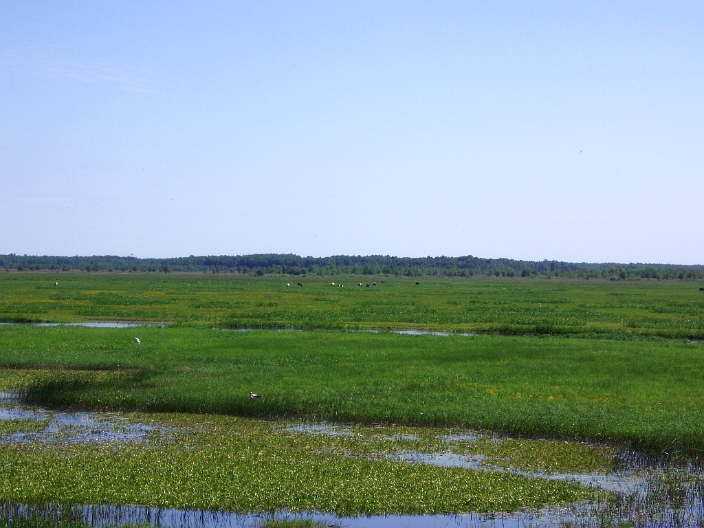
Understanding the floodplain structure
The Narew's braided character comes from its very low gradient — the river drops only about 0.15 metres per kilometre through the national park. At this gradient, the river cannot maintain a single channel; water spreads laterally and creates a network of anabranching channels. This produces the characteristic visual structure: a series of water-mirror surfaces at different distances, separated by low strips of vegetation.
The photographic implication is that the landscape has natural layering built in. From almost any elevated position — even standing on a bank 50cm above the water level — you can see three or four distinct horizontal bands of alternating water and vegetation. This layering is the foundation of most successful compositions on the Narew.

Using willow stands as compositional anchors
The Salix alba — white willow — is the dominant tree on the Narew floodplain. Its growth pattern is distinctive: trunks lean at angles set by past flood pressure, branches sweep low over the water, and root systems are visible above the bank surface in many locations. In composition terms, leaning willows serve a specific function that upright trees do not: they introduce diagonal elements into a landscape that is otherwise built almost entirely of horizontals.
The most effective use of a willow in a Narew composition is as a framing element in the near foreground — close enough that the canopy creates an irregular top edge to the frame, with the river and its layered channels visible behind and beneath. This requires positioning yourself underneath or beside the tree rather than at a distance from it. In many cases this means wading into the shallows or working from an unstable bank edge.
The alternative is to use the willow's trunk as a vertical element against a horizontal background. At 50–100mm focal length, with the trunk in the left or right third of the frame and the river receding behind it, the trunk's lean creates a diagonal tension that a vertical upright tree would not provide.
Wading: practical notes
A significant proportion of the best positions on the Narew require standing in water. The riverbed in the national park section is generally firm peat or sand, with occasional soft mud patches near vegetation roots. Wading without knowledge of the specific bank is unreliable — what looks like firm bottom from the bank is sometimes 30–40cm of soft sediment beneath a surface crust.
Practical approach to wading on the Narew:
- Test the bottom with a walking pole or monopod before committing weight. A pole pushed down 10cm without meeting resistance is a warning sign.
- Neoprene chest waders are excessive for most positions, which require no more than knee depth. Lightweight breathable waders or rubber knee-high boots are adequate for the majority of shooting positions.
- When using a tripod in the water, check that all three legs are on comparable bottom types before extending fully. A tripod with one leg on firm sand and two on soft peat will shift under the weight of a camera and telephoto lens.
- The nesting season (mid-April to late June) requires awareness of ground-nesting birds. Several tern and lapwing species nest on exposed gravel and sand banks. Approaching these areas on foot causes disturbance; the photographs are not worth it and the park regulations are explicit on this point.
The seasons on the Narew
Spring flooding on the Narew is less dramatic than on the Biebrza but produces its own characteristic conditions. From late February through April, water levels rise substantially and the boundary between channel and flood meadow disappears. Willows stand in water to their lower branches. The visual effect is of a forest flooded from below — isolated trunks in a continuous water surface rather than trees on a bank.
This is one of the most distinctive subjects the Narew offers. The reflection of bare winter willows in still floodwater, shot in low horizontal light, produces images that read differently from the green-dominant summer landscape. The access challenge is that many bank-edge positions are themselves flooded, requiring either wading or boat access.
By late May the water recedes, the willows come into full leaf, and the character of the landscape shifts to vertical density — tall reeds, overarching willow canopies, and the visual compression that green summer vegetation creates. Compositions that worked in April because of their open sight lines may be blocked by July. The landscape effectively resets itself each season.
Autumn on the floodplain
September and October bring the combination most often described in photography notes of the Narew: the willows turn yellow-gold, the reeds go russet, morning mist sits at consistent height in the channels, and the sun is low enough for most of the day that the light quality is close to what you would get only at the hour around sunrise and sunset in summer.
The specific condition of pale yellow willow foliage against a dark green or near-black reed bed background, with a strip of silver-grey water between them, is something the Narew valley produces in quantity for roughly six weeks each autumn. The narrow band of colour in the willows changes week by week as the leaf drops progress, and the compositions available shift accordingly.
Elevation and viewpoint
The Narew valley is by definition flat. The highest natural viewpoint above the floodplain level is rarely more than a few metres. The dyke roads that run along sections of the river — particularly near Rzędziany and Uhowo — offer modest elevation that is nonetheless sufficient to see across multiple channel bands simultaneously.
At 2–3 metres above the water surface, a standard zoom at around 50–70mm will capture three or four horizontal bands — near water, first reed strip, second water channel, second vegetation band, distant treeline — cleanly separated. This is the baseline compositional structure that most successful Narew landscape photographs are built on. Variations from this structure — low water-level positions, telephoto compressions, wide foreground approaches — are most effective when understood as deliberate departures from the norm rather than the starting point.
The Narew floodplain is one of the less-photographed major wetlands in Poland by comparison with the Biebrza, partly because it lacks the concentrated birdlife that draws wildlife photographers to the Biebrza basin and partly because its braided structure makes the landscape harder to read on a first visit. The landscape rewards the photographer who takes time to understand its structure. The compositions are not immediately obvious — they have to be found by walking the banks, reading the layering, and identifying the elements that create depth in what is otherwise a very flat environment.

